Why Does Lunt Meadows Flood?

Why Does Lunt Meadows Flood?

Alan Wright

Lunt Meadows is best known as a wetland nature reserve, but it has another extremely important function: to protect nearby communities from the devasting effects of flooding.

Why does Lunt Meadows flood?

Though better known by the public as a nature reserve, Lunt Meadows is also a flood storage reservoir, meaning that it is designed to flood at times of heavy rainfall when the River Alt, which runs alongside the reserve, is dangerously high and could cause flooding to nearby land.

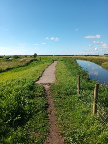
a spillway at Lunt Meadows next to the river Alt in sunny weather

Spillway one along the River Alt embankment. This is how the spillway looks when the river levels are safe and the embankments are used by walkers. Photo Credit: Molly Toal

Flooding from the River Alt

Directly next to Lunt Meadows is an embankment of the River Alt and there are two engineered spillways (weirs) along the Lunt side, which were installed by the Environment Agency (EA). These spillways allow water from the Alt to flow into compartments within the reserve during times of high river flow, such as when there has been lots of rain. The compartments within Lunt Meadows are designed to accommodate 1.3million cubic meters of water. The water sits in the nature reserve, and is then either absorbed by plants and soils, returns to the atmosphere, or is slowly released back into the river Alt at times of low flow via a gravity fed, one-way outlet back into the river.

Why do you close Lunt Meadows when the spillways operate?

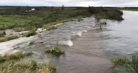
A large volume of water from the River Alt pours over the spillway into Lunt Meadows

A large volume of water from the River Alt pours over the spillway into Lunt Meadows. This event occurred in January 2020. Credit: LWT

Lunt Meadows is open 365 days a year for pedestrians, and our car park is only closed on Christmas day. The only exception to this is if the spillways have operated, and the site is flooded. Then the nature reserve and car park are closed to everyone, including volunteers. It can take a while for the water to stop pouring over the spillways, and for the water levels to drop. So this closure is necessary for health and safety reasons, even if some paths are still accessible. 

Do the paths flood too?

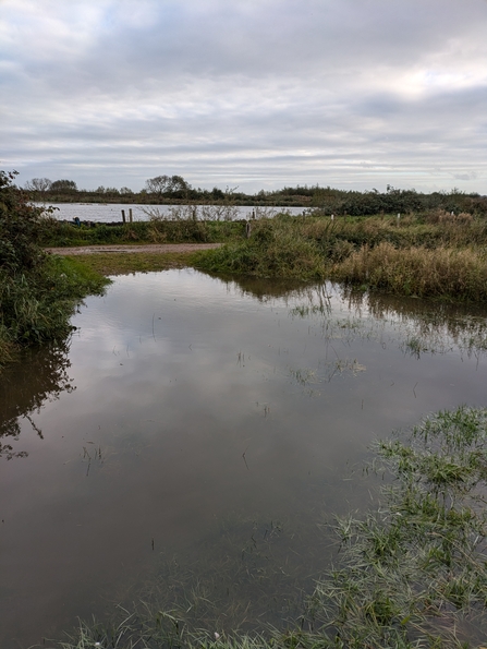
A very flooded path at Lunt Meadows

A path becomes one with a drainage ditch at Lunt Meadows. Photo Credit: Cheryl Ashton

Yes, our paths can be affected by high water levels and can flood.

Running through Lunt Meadows are also drainage ditches that are part of the surface drainage system across Sefton and West Lancashire. When the water in these ditches becomes too high, it is pumped back into the Alt via a small electric EA pumping station that is located along the embankment, known as Broad Lane Pumping Station. This entire system reduces the amount of water flowing downstream, as well as pressure on the region’s surface water drainage system and the EA pumping station at Altmouth.

There are times when there is more water entering the ditches than the ditches can hold, and it can take a bit of time for the pumping station to move the water out back into the River Alt. At these times, the water from the ditches rises and seeps across the paths within the nature reserve, making them waterlogged and muddy underfoot.

The location of paths was designed in such a way as to offer privacy and protection to the wildlife. The Lunt Meadows team are now planning on creating new, more accessible paths around the reserve. These paths will be designed with the wildlife in mind too, as we do not want to create increased disturbance. The development of these new paths is possible thanks to players of the National Lottery Heritage Fund supporting our habitat and engagement work at Lunt Meadows.

How often does Lunt Meadows flood?

A flooded path under deep water on Lunt Meadows nature reserve

A flooded path after heavy rains in October 2024 at Lunt Meadows. This path was so waterlogged you could not see it and the water would have gone above wellies. Photo credit: Cheryl Ashton

It is only during times high rainfall that the flood storage function of the site is enacted. However, with climate change increasing the frequency of extreme weather, this is happening more frequently and can occur any time of year.

How can I check if Lunt Meadows is closed or not before I visit?

Please check the Lunt Meadows reserve page on our website for any updates regarding closure due to flooding, especially if there has been heavy rainfall prior to your planned visit.

Find out more about Lunt Meadows


the national lottery heritage fund logo of a hand crossing fingers on a blue circular background. The text on the image says 'Made possible with Heritage Fund'

Our work at Lunt Meadows is possible thanks to The National Lottery Heritage Fund.